
EuroSDR: UltracamD data set
 |
EuroSDR networkDigital Camera Calibration |
UltracamD data set
The UltracamD data set was processed by 4 network members. Some of them used the two separate flying heights independently others did a combined approach where low and high flying height were considered in one adjustment approach. Since the participants provided several versions, altogether 15 different versions were evaluated.
The absolute accuracy was obtained from check point analysis. The Fredrikstad test site provides 50 signalized points roughly, not all of them visible in all flights. About 20 points were distributed as control points. Thus about 20 were available for check point analysis. In case the differences at some individual check point were significantly larger than the remaining ones, the pilot centre eliminated those point(s) from further analysis. This was done to minimize the influence of obvious errors in image measurements on the system accuracy analysis.
The (anonymized) results from all UltracamD participants are
given below. Please note, Ultracam low flying height corresponds to
1900m above ground (GSD 0.17m), Ultracam high corresponds to 3800m
above ground (GSD 0.34m). Besides that, the two blocks are of
different structure. Please also keep in mind the non favourable
flight conditions resulting in images of somehow reduced radiometric
quality. Details on the data itself were already given in
EuroSDR-Phase2-Data-UCDDisc.pdf (![]() )
)
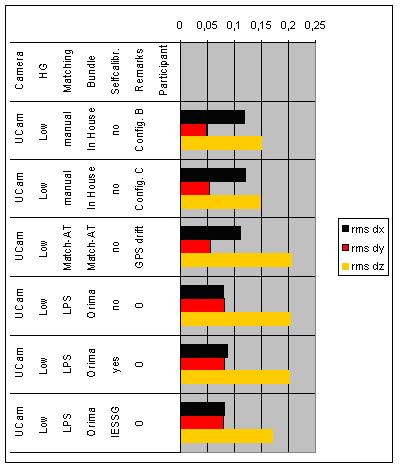 |
| Figure 1: UltracamD absolute accuracy (RMS values [m]) for low flying height (GSD 17cm) |
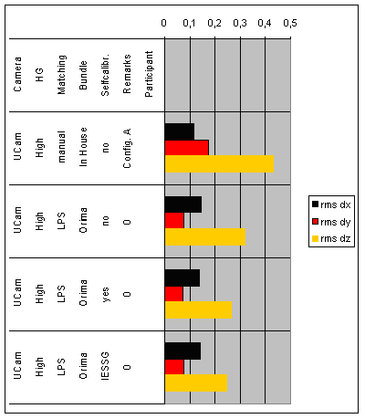 |
| Figure 2: UltracamD absolute accuracy (RMS values [m]) for high flying height (GSD 34cm) |
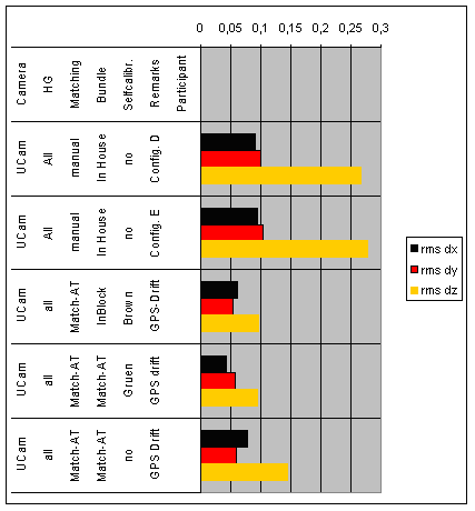 |
| Figure 3: UltracamD absolute accuracy (RMS values [m]), both flying heights considered in one adjustment. |